

Archive Record
Images
Metadata
Object Name |
Map |
Collection |
Oil Museum of Canada Collection |
Accession number |
OMC 2024.020 |
Catalog Number |
OMC 2024.020.001 |
Date |
1865 |
Dates of Creation |
1865 |
Area / Region |
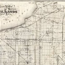
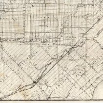
Lambton County with part Kent, Middlesex, and Elgin Counties |
Publisher |
Ellis |
Publication Date |
1865 |
Publication Place |
Toronto, Ontario |
Title |
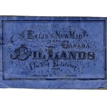
Ellis's New Map of the Canada Oil Lands |
Scope & Content |
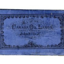
Map that folds into a blue cover with black lettering titled, "Ellis's New Map of the Canada Oil Lands 1865". The pocket map was lithographed by John Ellis, Toronto. The map is primarily Lambton County with parts of Kent, Middlesex and Elgin, however the counties are not named. It shows the location of the oil wells in Oil Springs, Petrolia, and Bothwell as well as the reserves, townships, lots, roads, railways, villages, lakes, rivers and creeks. |
Physical Characteristics |
Blue soft cover with the map folded to fit inside. 15cm x 9.4cm with the map unfolded to 45.4cm x 61.3cm. |
No. of Sheets |
1 |
Medium |
Paper |
Scale |
200 ch to 1 inch |
Size |
45cm x 61cm |
Extent of Description |
Map cover 15.2cm x 9.5cm, thick blue paper. |
Language of Material |
English |
Search Terms |
Creeks Elgin County J. Ellis Kent County Lake Huron Lake St. Clair Lambton County Lots Map Middlesex County Oil Oil Wells Railways Reserves Rivers Townships |
People |
Ellis, John |