


Archive Record
Images
Metadata
Object Name |
Map |
Collection |
Oil Museum of Canada Collection |
Accession number |
OMC 2015.003 |
Catalog Number |
OMC 2015.003.096 |
Date |
23 Apr 1940 |
Area / Region |
Oil Springs Area |
Publisher |
Department of Highways- Ontario |
Publication Date |
23/04/1940 |
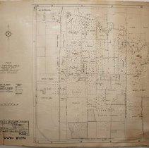
Title |
Plan of Oil Springs Area showing oil wells being Lots 16, 17, 18, 19 Cons 1 & II Township of Enniskillen in the County of Lambton. |
Scope & Content |
Laminated map showing oil wells in the Oil Springs Area being lots 16, 17, 18, 19 in Concession 1 and 2 Township of Enniskillen in the County of Lambton. It has been surveyed March 1940 by W.J. Fulton, Chief Surveyor from the Department of Highways- Ontario Surveys Branch. The map shows wells in operation, wells temporarily not in operation, wells abandoned; casing left in and wells abandoned; casing removed. The map also shows the property owners as follows; Robertson Estate, Dan Jewell, Sproule & Johnston, J.T. Hillis & Son, Morningstar & Jackson, Fairbank Property, Charles Mitchell, Anderson Thompson, Canada Crude Oil Producers, J. Warwick, Touchburn, William Woodward, B. Sutherland, L. Morningstar, N. Byers, McGillivary, Wallen Wallen, Crocker Parks, E. Mott, J. Lewis, C. Dennis, Robert Mitchell, Sproule Bros. A.C. Wallen Estate, and Geo. Donald. |
No. of Sheets |
1 |
Medium |
Paper |
Scale |
1 inch to 400 ft |
Size |
77.5cm x 63cm |
Extent of Description |
13.7cm x 21.3cm |
Search Terms |
Canada Crude Oil Producers Crocker Parks Oil Company Enniskillen Township Lambton County Map Oil Producer Oil Properties Oil Springs Oil Wells Robertson Estate Oil Property Sproule & Johnston Oil Property Sproule Bros. |
People |
Anderson Byers Donald, George Fairbank Hillis, James T. Jackson Jewell, Dan Johnston MacGillivary, Lester MacGillivray McGillivary Mitchell Mitchell, Charles Morningstar Morningstar, L. Mott Robertson Sproule Sutherland Thompson Touchbourne Wallen Wallen, A.C. Warwick, J. Woodward, William |